Tour Scenic Mount Baker Highway
From sea level, through timber country to the base of the 10,781-foot volcano, take a 60-mile day drive on state Route 542 in the northwest portion of Washington State. Plan on taking a couple of hours each way. There is no hurry. The mountain will be waiting for you.
A glistening, snow-capped summit scrapes the sky high above the Salish Sea. From a distance, the mountain looks imposing and remote, but appearances can be deceiving. Reaching Mount Baker is easy via a scenic drive through the wilds of the Pacific Northwest. For roughly 60 miles, the Mount Baker Highway, also known as state Route 542, runs from the city of Bellingham to the base of the 10,781-foot volcano. The route traces parts of the scenic Nooksack River before climbing past shimmering lakes and huckleberry meadows to an elevation of 5,140 feet.
Take your time as the road is winding and narrow. Pull off and enjoy the scenery. The views of Mount Baker and nearby Mount Shuksan are stunning.

At Sea Level
Start your journey in the quirky coastal town of Bellingham. This vibrant community is a hodgepodge of artists, laborers, college kids and retirees.
Breakfast enthusiasts will enjoy the Homeskillet, a local favorite for skillets of deliciousness for all diets. Coffee lovers should check out Woods Coffee. Beer connoisseurs can sip on the suds at Aslan, Kulshan and Boundary Bay breweries. Burger lovers should head to Boomer’s Drive-In for a retro car experience, or Bob’s Burgers & Brew for a sit-down spot. Rock and Rye Oyster House is a seafood favorite.
Also don’t miss the exhibition, “People of the Sea and Cedar: A Journey Through the Tribal Cultures and History of the Northwest Coast.” The display is located in downtown Bellingham at the Lightcatcher building of the Whatcom Museum. The exhibit features more than 50 artifacts and images, including clothing, hand-made tools and baskets, as well as videos showing Lummi and Nooksack weavers and carvers. It sheds light on what life was like here before the forces of the fur trade and colonization forever changed the landscape.
Before you hop on state Route 542, consider taking the short trip out to Whatcom Falls and Lake Whatcom via Lakeway Drive. More than 3 miles of trails in Whatcom Falls Park wind through deep forest, the creek gorge and open meadows. It will whet your appetite for the breathtaking scenery of Mount Baker.
Once on Mount Baker Highway, however, you’ll find some of the best eagle watching in the contiguous United States just 15 miles outside of Bellingham. From December to March, hundreds of eagles migrate from Canada and Alaska to feast on the spawning chum salmon around the community of Deming. Two good viewing sites are the Nooksack River Bald Eagle Viewing on Mosquito Lake Road and Deming Homestead Eagle Park on Truck Road.
Past Mosquito Lake Road, the mostly paved North Fork Road leads to Racehorse Falls. Plunging down 140 feet over four tiers, the waterfall is reached by a short, mile-long hike. If that gets you hungry, grab a bite at Grant’s Burgers before getting back on the road to Mount Baker.

Entering Timber Country
Nine miles from Deming, you’ll reach Kendall, once the site of a limestone quarry. One of the most beloved spots in Kendell today is North Fork Brewery, a casual place known for its home brews, hot slices of pizza and a collection of beer antiques and memorabilia. Three more miles up the road and you’ll reach the town of Maple Falls, which was once a vibrant timber town. The main stop here is the Mount Baker Visitor Center in the historic Maple Falls town hall. Aside from issuing recreation permits, the welcoming visitor center provides updates on road conditions, wildflowers, fall colors and the snowpack.
The town of Glacier is 7.5 miles from Maple Falls. So named from the nearby Glacier Creek, this tiny settlement was once a commercial hub for gold and coal mining and timber companies. Today it is the laid-back last stop before entering the national forest. Stretch your legs and enjoy the ski culture at Wake ’n Bakery or the Chair 9 Woodstone Pizza & Bar. The Glacier Public Service Center for the Mount Baker-Snoqualmie National Forest has information to help you plan your visit, but the building itself is worth a look. Built in 1938 and listed on the National Register of Historic Places, it is a fine example of the Cascadian style of architecture.
Past Glacier, the route becomes more remote, and the Nooksack River occasionally pops into view. Roughly 7.5 miles from Glacier, National Forest Development Road 33 leads to stunning Nooksack Falls. The viewpoint for the 88-foot falls is reached after a tenth of a mile trail. When snowy, the access road is closed, making this a mile-long trek. Avid hikers looking for late-summer bliss on ridges should try the 7.2-mile round-trip Skyline Divide Trail.
In the summer, drivers who are comfortable with a rough dirt road should head up National Forest Road 3065, 5.5 miles from Nooksack Falls. After a little more than 4 miles on the bumpy road, keep an eye out for the Yellow Aster Butte trailhead, one of the most spectacular trails in the North Cascades. The 7.5-mile round-trip trail gains 2,550 feet in total, leading to meadows of dazzling wildflowers in the late summer and amazing fall colors.
The road continues for another 2.3 miles, where high clearance vehicles can reach the trail leading to Twin Lakes and Winchester Mountain. Winchester Mountain is 3.4 miles round trip with 1,300 feet of elevation gain. The short, steep hike leads to a summit with commanding views of Mount Baker, Mount Shuksan and the North Cascades. If long dirt roads and steep hikes aren’t your speed, Shuksan Picnic Area is a more accessible spot of beauty right off Mount Baker Highway.

Into the Mountains
This final 10.6-mile stretch of Mount Baker Highway is gorgeous, weaving through the forest on a twisty road with occasional mountain sightings. The higher the road climbs, the better the views become. By the final switchbacks, the snowcapped summits are on full display.
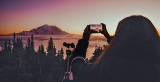
Your first stop should be Picture Lake. The view here is worth the trip. At the end of a short, Americans with Disabilities Act-accessible trail you’ll encounter an iconic view of Mount Shuksan. Past Picture Lake, the seasonally opened Heather Meadows Cafe is a good place to grab a bite or a drink.
In 1998-99, Mount Baker set a world record for most snow in a year with 1,140 inches. No wonder the area is so popular with skiers and snowshoers in the winter. The Mount Baker Ski Area is found at the end of the highway, giving skiers and snowboarders a play of 1,000 acres of runs. Snowshoers also flock to Artist Point, the end of the line on the Mount Baker Highway. Inquire locally for the latest conditions and open trails.
Heather Meadows Visitor Center, originally built in 1940 as a ski warming hut, sits on a rock ledge that overlooks Bagley Lakes. It is open in mid-July to late September. Aside from the stunning view here, visitors can buy books and maps, and get other information. The nearby Austin Pass Picnic Area, which is open in late summer and early fall, is also another stunning sight with access to all levels of hiking trails. Bagley Lakes is an easy 2-mile round-trip trail, family-friendly and incredibly scenic, while Chain Lakes is a well-traveled 6.5-mile moderate loop to breathtaking lakes, glaciers and sweeping vistas. More difficult, but rewarding hikes are Lake Ann and Ptarmigan Ridge.
The road ends at Artist Point, which affords 360-degree views of Mount Baker and Mount Shuksan and leads to numerous trails. Be aware that the upper reaches of the Mount Baker Highway and Artist Point can be closed to cars well into the summer.
Artist Point should not be missed. On a clear summer day, the views from the parking lot are some of the most majestic mountain sights in America. Your drive to these glacial peaks from the salty shore is now complete. There stands Mount Baker revealed.
–Written by Douglas Scott, last updated in October 2022.